Master Plan
Master Plan — Century OneWorld Seraya, Devanahalli
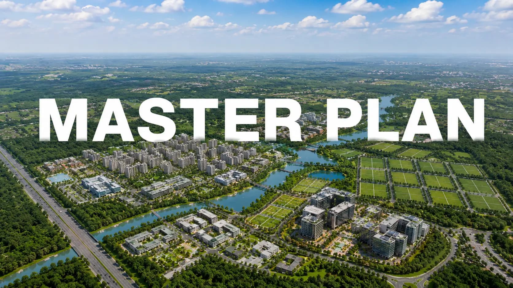
The Century OneWorld Seraya master plan spans across a 135-acre integrated township at Tarabanahalli / Channahalli Village, just before the Devanahalli Toll on NH-44. Three plotted phases, totaling 55 acres, are part of the larger township that also includes 25 acres of residential apartments, commercial and IT office space, a planned international school and a planned university property. The final plotted release within the master plan envelope is Phase 3.
This site demonstrates how the levels of the masterplan are combined. It encompasses the positioning of the 25-acre Phase 3 property, the road hierarchy, the park and open-space network, and the wider Century OneWorld township North Bangalore territory already absorbed two sold-out projected phases.
The 25-acre Phase 3 parcel adjoins the sold-out Phases 1 and 2. A 24 metre artery spine runs through the township. Each plot line is linked to open space within a 100 metre walk by pocket parks and the landscape spine.
✦ Township Composition: How 135 Acres Divide
The 135-acre area is spread among six use-zones. They have each been designed to BIAAPA approval criteria and included into the road and utility network for Phases 1 and 2.
Use Zone | Approx. Land Area | Status |
Plotted Development (Phases 1, 2, 3) | ~55 acres | Phases 1 & 2 sold out; Phase 3 pre-launch |
Residential Apartments | ~25 acres | Planned within the master plan |
Commercial & IT Office | ~20 acres | Planned mixed-use zone |
Planned University Parcel | ~15 acres | Reserved zone within the township |
Planned International School | ~10 acres | Reserved zone within the township |
Internal Roads, Parks & Open Spaces | ~10 acres | Integrated across all phases |
✦ Phase 3 Parcel: Where the 25 Acres Sit
The Century OneWorld Seraya Phase 3 master plan parcel is the final 25-acre plotted block in the township. Location matters. Phase 3 is next to Phases 1 and 2 in the same 24-metre arterial spine, drainage network, perimeter security envelope and landscape architecture vocabulary.
The Century OneWorld Seraya 25 acres parcel is subdivided into roughly 100 plots, with five plot sizes available: 1,200 sft (very limited), 1,500 sft (30×50), 1,800 sft, 2,400 sft (40×60), and a small batch of unusual / odd-shaped configurations for corner and park-facing situations. Plot lines feed off 12-metre minor roadways that link to the 24-metre arterial spine running through the community.
The park-facing margins and corner junctions are the most valuable locations within the Century OneWorld Seraya property pattern. These are usually assigned to the special / odd-sized inventory pool. The plot plan of Century OneWorld Seraya assures that every plot is a 100-metre walk from a pocket park or a node on the landscape spine.
✦ Road Hierarchy & Internal Movement
The master plan works with a three tier road hierarchy. The artery spine, 24 metres wide, carries the bulk of internal vehicle movement. This is the road leading the township to the NH-44 entry gate. Secondary roads 12 metres wide split off from the arterial to serve groupings of clusters of plot. Tertiary roads 9 metres wide feed individual plot lines from the secondary roads.
All roads have kerbs, footpaths and stormwater channels. LED street lights all the way through. The Century OneWorld township North Bangalore arterial spine itself has been designed keeping future proofing in mind. The road width is sufficient for two-way traffic as well as designated pedestrian and cycling accommodations.
✦ Parks & Open Space Network
(13,628 sqm of open space) per the Phase 2 RERA file. About 14% of the Phase 2 land was allocated to parks and open spaces. Phase 3 is the same standard. The open space network includes pocket parks sprinkled throughout the plotted layout, landscaped medians along the arterial spine, and a dedicated landscape spine that runs the length of the township.
Pocket parks within 100 metres of every plot line
Landscaped medians along the 24-metre arterial spine
Dedicated landscape spine with walking and jogging tracks
Tree-lined avenues across the plotted zone
Children's play areas within the park network
Toddler-zone soft-fall landscaping
Family seating alcoves through the landscape spine
✦ Reserved Zones: University, School & Commercial
Three reserved zones within the master plan are programmed for later-phase build-out:
Planned International School — ~10 acres reserved within the township for an international school, programmed to serve resident families across the plotted and apartment phases.
Planned University Parcel — ~15 acres reserved for a university-grade education campus — the master plan anticipates an institutional partner for build-out.
Commercial & IT Office Cluster — ~20 acres planned for a mixed-use commercial and IT office programme, offering on-site retail and work options for township residents.
✦ Sustainability & Civic Infrastructure
The master plan combines the civic infrastructure for all six use-zones into one approved package. BIAAPA authorized layout planning. KSPCB compliance (including drainage and treatment) BESCOM supplies power with the supply of transformer and substation within the municipality. Meenukunte Grama Panchayat has flowing water. The entire infrastructure stack runs through the underground utility ducting that runs under the road grid.
BIAAPA-approved layout plan (Phase 2 plan no. BIAAPA/TPA/LAO/36/2024-25; Phase 3 follows the same framework)
KSPCB-compliant drainage and treatment systems
BESCOM transformer and substation provision inside the township
Meenukunte Grama Panchayat water supply (per Phase 2 RERA)
Underground utility ducting (electrical, telecom, fibre)
Stormwater drainage and rainwater management
LED street lighting across all internal roads
24x7 CCTV coverage on common areas; perimeter-secured entry
✦ Phase-by-Phase Comparison
These three plotted phases collectively comprise the 55-acre plotted block in the master design. Each of the three phases has its own KA RERA registration, however they all share the same arterial spine, shared facilities and BIAAPA approval structure.
Phase | Phase 1 | Phase 2 | Phase 3 |
Land Area | ~13 acres (approx) | ~17 acres (approx) | 25 acres |
Total Plots | 123 (122 res + 1 com) | 167 (166 res + 1 com) | ~100 (curated) |
Status | Sold Out | Sold Out | Pre-launch / EOI |
RERA Reference | PRM/KA/RERA/1251/309/PR/050725/007894 | Approved 01-09-2025 | Pending — announce at launch |
Open Space Reserve | Per plan | 13,628 sqm (~14%) | Same standard |
✦ Continue Exploring
For full proximity matrix and drive-time tables, head to our Location page. The Floor Plan page covers plot dimensions and sample villa layouts; the Price page covers the cost-sheet breakdown and Phase 1-3 pricing trajectory.
The Amenities page lists the seven amenity zones. Engineering and BIAAPA / KA RERA disclosures live on the Specifications page; walkthrough imagery on the Gallery page. To walk the live build-out or submit an EOI, head to the Contact page.
Frequently Asked Questions
Book a Site Visit —
Master Plan
Share your details and our sales team will reach out shortly to arrange a private walkthrough.